• 中文版
  • BM
  • News
  • Deals
  • Reviews
    • First Impressions
    • Hands-on
    • Comparisons
  • Tech
    • Mobile
    • Computers
    • Cameras
    • Wearables
    • Audio
    • Drones
  • Telco
    • Celcom
    • Digi
    • Maxis
    • Time
    • Tune Talk
    • U Mobile
    • Unifi
    • Yes
  • Cars
  • Contribute
  • Jobs
Menu
  • 中文版
  • BM
  • News
  • Deals
  • Reviews
    • First Impressions
    • Hands-on
    • Comparisons
  • Tech
    • Mobile
    • Computers
    • Cameras
    • Wearables
    • Audio
    • Drones
  • Telco
    • Celcom
    • Digi
    • Maxis
    • Time
    • Tune Talk
    • U Mobile
    • Unifi
    • Yes
  • Cars
  • Contribute
  • Jobs
Search
  • Tech
    • News
    • Mobile
    • Computers
    • Cameras
    • Wearables
    • Audio
    • Drones
  • Telco
    • Celcom
    • Digi
    • Maxis
    • Time
    • U Mobile
    • Unifi
    • Yes
  • Reviews
    • First Impressions
    • Hands-on
    • Comparisons
  • Buyer’s Guide
  • Opinions
  • Digital Life
  • Video
  • Deals
  • How-To
  • Cars
  • Bahasa Melayu
  • EV
  • Contribute
  • Advertise
Menu
  • Tech
    • News
    • Mobile
    • Computers
    • Cameras
    • Wearables
    • Audio
    • Drones
  • Telco
    • Celcom
    • Digi
    • Maxis
    • Time
    • U Mobile
    • Unifi
    • Yes
  • Reviews
    • First Impressions
    • Hands-on
    • Comparisons
  • Buyer’s Guide
  • Opinions
  • Digital Life
  • Video
  • Deals
  • How-To
  • Cars
  • Bahasa Melayu
  • EV
  • Contribute
  • Advertise
Search
Close
Home Digital Life

Now you can explore Gunung Tahan on Google Street View

  • BY Alexander Wong
  • 15 September 2016
  • 2:11 pm
  • Comment
Share on FacebookShare on Twitter

160915-google-streetview-malaysia-gunung-tahan

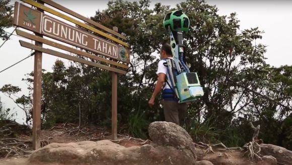
Just in time for Malaysia day, Google wants to take you on a tour at Gunung Tahan via Street View. This is the highest peak in Peninsular Malaysia at 2,187 metres. The new addition joins other national parks which include Kinabalu Park, Mulu Park and Taman Negara Pahang. These virtual experiences were made possible with the volunteers from Google Malaysia and the Malaysian Nature Society.

While most typical street view locations are captured by a street view car, capturing off-road locations are more challenging and it’s made possible with the Street View Trekker. This is specially designed backpack with a mounted 360 degree camera on top.

According to Google, the Kuala Tahan-Kuala Tahan trail takes 7-8 days to trek on a return trip from Kuala Tahan to the summit. To capture the trail for street view, they had to overcome undulating ridges and river crossings on foot. With Street View, Google wants to showcase the many attractions that are available in Malaysia and hopefully that would attract more people to visit themselves. You can start exploring Gunung Tahan yourself over here.

Apart from Gunung Tahan, Google has also added the following locations in time for Malaysia Day.

1. KL Sentral
2. KLIA and KLIA2
3. Aquaria KLCC
4. National Library / Perpustakaan Negara
5. Galeria Sri Perdana
6. Kuala Gandah Elephant Sanctuary
7. National Planetarium / Planetarium Negara
8. Museum of Asian Art
9. Kek Lok Si Temple
10. Kuching Friendship Park

Tags: Explore Gunung TahangoogleGoogle Street ViewGoogle+ MalaysiaGunung TahanStreet View Malaysia
Alexander Wong

Alexander Wong

POPULAR

Now you can explore Gunung Tahan on Google Street View

September 15, 2016

Why are Malaysians still buying EVs in 2026? | Let’s Talk About #138

March 15, 2026

iPhone to support 5G SA for Yes 5G, U Mobile and Maxis via iOS 26.4

March 16, 2026

Is Your Current Phone Generations Behind? Here’s a Simpler Way to Close the Gap

March 13, 2026

BMW i3: Fully electric 3 Series, 800V EV with up to 900km range and 400kW DC charging

March 18, 2026

Poco X8 Pro: Flagship-class performance and up to 8,500mAh battery for under RM2,000

March 17, 2026

Copyright © 2025 · SoyaCincau.com
Mind Blow Sdn Bhd (1076827-P)

  • ADVERTISE
  • DISCLAIMER

Copyright © 2026 · SoyaCincau.com – Mind Blow Sdn Bhd (1076827-P)

  • ADVERTISE
  • DISCLAIMER